April’s weather took a slight turn for the worst after a warm and pleasant Easter break. The British weather was largely influenced by high pressure to the North and East preventing low pressure from easily tracking across the UK as it typically does. This meant fronts generally arrived from the South-West, so England was wetter than usual, and Scotland slightly drier. The temperatures were changeable, typical of spring weather.
We begin May with a ridge of high pressure moving off the UK and making way for an unsettled spell for the Coronation weekend. The good news is this allows some slightly warmer air to move in for the first half of May.
Low pressure will tend to be in control through May, although weather systems will be weaker than usual thanks to a weaker jet stream, so some drier, settled spells are likely between bands of rain and showers. On the flipside, an increasingly stronger sun angle this time of year provides extra energy which can help build showers, occasionally building into more organized thunderstorms. This is something to look out for when low pressure is present during the warmer months of the year.
With low pressure in charge, the weather is expected to be changeable, with the strongest signal being wetter than usual weather and cloudier skies. Temperatures should fluctuate as fronts pull in air from different directions, but there are few signs for any significant hot or cold spells, with predominantly Westerly winds.
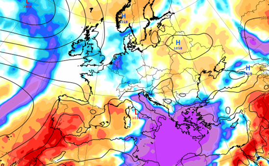
The map (above and in our summary image) shows the forecast rainfall anomalies from the six-week longer range ECMWF weather model. The blue shading over the UK and Ireland highlights the wetter weather expected through May. We can also see dry anomalies forecast over Spain and Portugal, who have just had a hot and dry April, so keep an eye out for any talk of heatwaves or drought over there in the news.
Towards the end of May the signs are looking positive with increasing chances for more settled and drier weather to begin meteorological summer.
About this author