Summer is well under way and this past June was one for the record books. Not only was it the hottest June on record for the UK, but it was the hottest June in terms of the global average temperature as well.
For the UK, we managed this without any notable very hot spells, but instead had consistently warm weather with virtually no days below average after the 6th of the month. June also saw frequent low pressure, so it was a generally wet month, even though Scotland tended to be a little drier than normal.
Heading into the rest of July, we’re expecting persistent low pressure near northern Europe, essentially for the rest of the month. This means, with a few exceptions, we’re looking at a slightly cooler, wetter, and breezier month compared to normal. This is going to come with a lot of changeability and unsettled weather though, so we should still see some warmer, dry and sunny days too.
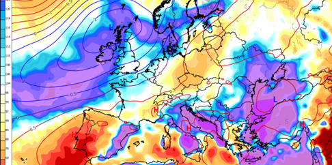
The long-range forecast for rainfall from the European model is shown in the image at the top of the page, and here we’re looking at the departure from normal. Plenty of wet weather is in store for the British Isles, although south-eastern England is just near-normal. This is thanks to the persist low pressure pattern in northern Europe keeping weather fronts and afternoon showers in place most days.
At the moment, there’s no strong signal for this pattern to break before the end of the month, and indeed in the first half of August either. Late July has a slight chance (25%) of some more consistently dry, sunny, and warm weather, but the chances of a heatwave are very low.
Across the globe, El Nino, which is a warm temperature anomaly in the equatorial Pacific waters, is increasing in strength and is likely to influence weather patterns for the rest of the year. This will impact things across Asia and into North America and can even influence European weather too.
About this author