September gradually put an end to the summer weather and gave us a good insight into what is to come for October. Temperatures above 20C were recorded in London only two weeks ago, but were swiftly followed by a cool end to the month, with some unseasonably cold nights across the UK. The first few days of October have seen some milder air return, albeit with rain and showers for many, which unfortunately looks likely again this week and ahead.
For October in general, we’re expecting increasingly unsettled wet and windy weather, all thanks to a strengthening jet stream.
The jet stream is a narrow band of fast-flowing winds high up in the atmosphere blowing from West to East across the Atlantic Ocean. It separates colder air near the Arctic and warmer air towards the equator and is important in driving weather systems down at the surface. The jet stream tends to lie over the UK, but its average position shifts North-South by season and it varies in its shape (how wavy it is).
A strong jet stream is forecast for this week and for much of the month. This means a less wavy jet stream that pushes low pressure systems across the ocean at a faster rate, leading to more changeability in our weather. With winds tending to blow more from the West we expect milder oceanic air in place, so a warmer than normal October is also on the cards. However, regions further North and West are likely to be cooler as they are in closer proximity to the boundary with colder air masses.
More wind and rain are the big story for October, as the strong jet stream promotes the passing of more powerful low pressure systems over the British Isles, a typical part of the transition into the Autumn months.
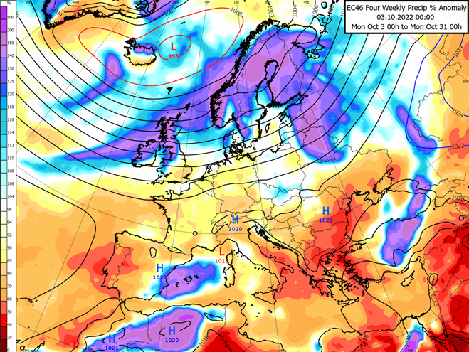
The map above shows a long-range computer model’s forecast for this month’s rainfall compared to normal. The purple/blue shading over Scotland, Ireland and North-West England are showing more rain than normal in these regions. This is thanks to the more frequent passing of warm and cold fronts around those low pressure systems.
Notice yellow/orange shading in South-East England suggesting drier than normal weather here. This is partly due to frontal rain bands being rained out by the time they’ve crossed Western and Northern areas which is a common occurrence, but occasional passing of high pressure is also more likely here which tends to favour settled and drier weather. Although drier than usual for October still means a decent amount of rain and some showers.
The main caveat to this forecast is related to how active the Atlantic hurricane season will be over the next few weeks. Although we have passed the peak of hurricane season back in mid-September, tropical storms are still common through October and even possible into early November. If any of these systems decide to begin travelling towards us, disruption to the expected weather patterns over in Europe is likely.
About this author