This July we saw the UK’s hottest ever day on record, with 40.3°C recorded in Lincolnshire on the 19th July. This beat the previous record back in 2019 by 1.6°C (source: Met Office). The heat was truly unprecedented; it was the first time in history that 40 °C was exceeded in the UK. The heatwave was widespread with Wales and Scotland setting new national records and temperatures in the mid-to-upper 40s in Spain and Portugal.
This heat was caused by a ‘Spanish plume event’, whereby very hot air from Spain or even North Africa travels north and manages to reach the UK. These events are common in the summer months, but the heat of this July’s plume event was exacerbated by the very dry conditions we’ve seen this summer throughout Western Europe and the continuing effects of climate change, among other factors.
As you may have heard in the news (or seen on the fields outside, depending on where you live), we’ve had a very dry summer, particularly in southern and eastern England. The combination of heat and a lack of rainfall are the perfect conditions for droughts and wildfires. High pressure looks to become widespread for the first half of August, meaning more hot and dry weather, so little relief for the worst affected regions.
High pressure is currently moving in from the Atlantic this week bringing with it some milder air. The temperatures will drop more the further north or west you are, but nothing much lower than normal for this time of the year. This high pressure system is forecast to build in strength over the UK this weekend and remain fixed in place until, at least, later next week.
High pressure is the key to settled weather so plenty of sunshine and little rain will be the highlight for many. Scotland, Ireland and Northern Ireland don’t look as heavily influenced by the high pressure, so expect a few showers and occasionally more persistent rain bands here.
With the jet stream moving north of the British Isles things should begin to warm up next week. There is also the risk of another plume event mid-August, though there remains a lot of uncertainty around this. If this does occur, another very hot heatwave lasting between two to five days is possible, with the South-East most sensitive to extreme heat. These events can, however, cause thunderstorms, breaking up the heat and humidity, and bringing some much needed rain.
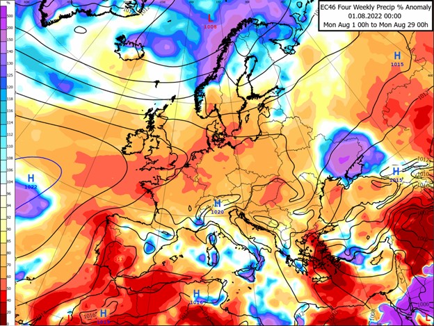
The image above is from a long-range weather model and shows precipitation anomalies for the month of August, with red/orange shading showing drier than normal and blue/purple showing wetter than normal. As we can see all regions of the UK are forecast a dry August, especially in the south. The latter half of August does have signs of low pressure becoming more prominent, so a wetter and more unsettled pattern. However, nothing overly-wet is expected and as such is barely influencing the map above.
To summarise, August is looking positive for those with holiday plans in the UK over the next two weeks, with widespread warm and settled weather. This will hopefully be followed by some wetter weather to ease the drought and fire hazard risks as we head towards the summer’s end.
About this author