
High pressure sticking over the UK for slightly longer than expected meant that a pattern of dry weather with low winds was dominant for much of March. As forecast, the month was warmer than normal, with overall day-time maximum temperatures 1.9 C above average for the UK.
The highlight of this settled weather was the widespread clear skies, which saw March sunshine records broken for Scotland and Northern Ireland. This was combined with frequent low-wind days and the blocking of weather fronts by high pressure, leading to well-below average rainfall in the West and North, with only 50% of normal precipitation falling in large parts of the Scottish Highlands.
One month into meteorological Spring and it may feel as though winter is still here, with widespread snow showers recorded, even in Southern England, on the final day of March.
We begin the month with almost a repeat of the cold snap seen last week. A deep low pressure system will pass over the UK during Wednesday evening into Thursday, ending up over Scandinavia. This allows winds to blow from the North, bringing some colder Arctic air to the British Isles that will stay with us until the beginning of next week. As this colder air arrives, snow will fall over the higher grounds in Scotland, Wales, and Northern England where some of it will settle. Where snow does accumulate, it may take a few days to melt as we remain in the colder air.
As this low pressure moves over us, we will see widespread strong winds, with Southern England and Wales particularly windy for this time of year.
Thankfully, once the jet stream sends us our next low pressure system early next week, things will begin to feel much milder. The yellow shading on the MetDesk map in our summary image suggests temperatures of 0.5 °C – 1°C above average for much of the UK during April, though further North there is less of a signal, and it may even be slightly cooler in the very North of Scotland.
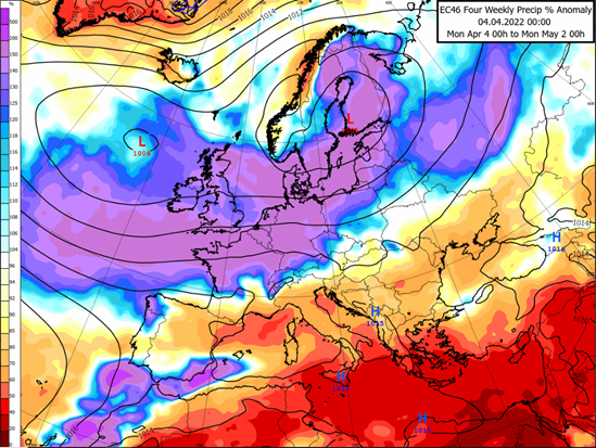
Moving into mid-April, low pressure near Iceland is expected to remain the dominant feature (shown by the centre marked ‘L’ on the MetDesk map above). This means wet and windy weather for the UK and North-Western Europe, though the winds will blow more frequently from the South and West, meaning more typical spring-like temperatures are expected. Low pressure does however, mean more day-to-day changeability as weather fronts transport milder and cooler air masses over us. It is the passing of these weather fronts that is causing our particularly rainy forecast, shown by the large area of purple shading on the map above.
Looking at the Easter weekend, there are growing indications for high pressure to make more of an appearance, which will lead to some drier and warmer weather with clear skies, as nearby weather fronts are weakened. This does appear to be short-lived, with a return to the general trend of low pressure, supporting mild, wet, and windy weather still looking likely towards the end of the month. Though this will be to a lesser extent compared to early April, with increasing interludes of more settled weather between the passing of fronts expected.
We will update again in early May, after hopefully seeing some warmer and drier weather over the Easter period, in between a generally windy and wet April.
About this author