
Welcome to meteorological spring. We are back after a busy winter, and looking back on December, January, and February it was a mild and mostly dry season across the UK. Heathrow Airport even flirted with its all-time December maximum temperature near the end of the month, but the record remains standing for another year. February took a significantly wetter turn after a dry December and January, but maintained the mostly above average temperature trends.
January and February were also stormy months at times, and so far in the 2021/22 storm season we have seen seven storms that have been named six by the UK Met Office and one by the Danish Meteorological Institute). This is not an unusually high number, but this season we also saw three Red Warnings for wind from the Met Office; one for Storm Arwen back in November and another two for Storm Eunice in mid-February.
These were both very powerful storms with Arwen bringing a maximum wind gust of 98 mph in Northumberland and Eunice sending an eye-watering 122 mph to the Needles Old Battery, on an exposed part of the Isle of Wight, which is the highest wind gust on record in England. Dudley, Eunice, and Franklin all struck within a week of each other, which exacerbated the impacts.
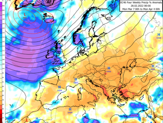
Looking ahead for March, we are anticipating a month with a dominant low pressure system in the North Atlantic near Iceland which will dictate our weather patterns in the British Isles and keep things unsettled and mild – with one exception - the period 5 to 11 March.
In early March we are expecting high pressure to briefly build across northern Europe and into Scandinavia, where it will remain for a few days next week. With high pressure in this location, an easterly wind will develop from Russia into continental Europe and bring in some of the cold winter air that is still in place there. Temperatures are likely to be widely below average across the continent next week, including in the UK where some sharp frosts are expected coupled with afternoon highs struggling to break into double figures.
The cold spell should last for four to five days before temperatures moderate and rise back above average for the second half of the month. This warmer air will come with wetter and windier conditions too as low pressure takes charge of the pattern and lingers to the northwest of the British Isles. High pressure is likely to shift into western Russia before building in the Mediterranean Sea / Iberian Peninsula later in the month.
Meanwhile, we are expecting the jet stream to ramp up later in March and keep things mild and unsettled. As high pressure strengthens to our south though, we can expect some brief dry and cooler spells. However, these will likely be fleeting as the jet stream drives frequent weather fronts in from the North Atlantic.
In short, it looks like the first month of meteorological spring will take on a decidedly British note of being rather wet and windy, but temperatures should often be above average and feel a little more like April, especially for the second half of the month.
For an example, the Met Desk maps (on our main page and here) show the forecast temperature (left) and precipitation (right) anomalies for March, indicating a wetter and warmer than normal period for the UK and Ireland.
We’ll be back in April to see if the wet, warm weather is likely to continue or if we might expect some drier, sunnier weather instead.
About this author