January was largely a month of two halves, with the first two weeks' weather dictated by an active jet stream driving mild and wet Atlantic low pressure systems across the British Isles. Some high pressure locking in place then led to a week of below average temperatures across the UK and Ireland which brought snow and wintry weather to higher ground in Scotland and widespread frosts elsewhere. Overall, thanks to the warmer spell early on, the mean UK temperature for January ended up just on the positive side of normal.
The beginning of February has marked a brief return to milder weather, but high pressure looks to make a reappearance next week and drop the temperatures. This shouldn’t be any exceptional cold such as that seen last month or mid-December, but certainly feeling colder than the last few days.
Where there are clear spells overnight (mostly England) the temperatures will drop below freezing so some chilly mornings and allowing fog and mist to form in places. Once this clears however, the high pressure should allow for some nice and clear conditions for the Southern half of the country. Scotland unfortunately lies further away from high pressure, so more overcast and unsettled weather is likely with the occasional heavier band of rain passing.
Looking ahead the signals are for high pressure to eventually make way for the arrival of Atlantic weather systems as the jet stream ramps up during mid-February. In winter, these low pressure systems bring unsettled mild and wet weather. So we can expect more frequent showers and rain along with near-normal to above-normal temperatures.
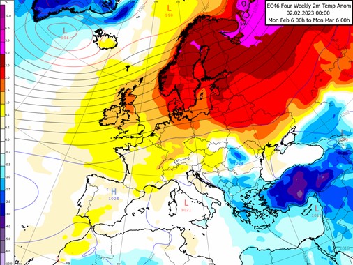
This is expected to be the main weather pattern for the latter half of February. The map above shows the average temperature and pressure for the next four weeks and demonstrates this overall mild pattern. We can see a low pressure centre just West of Iceland and high pressure well away to the South-West. This suggests a more active jet stream across the British Isles which in turn leads to the warm anomalies (yellow and red shading) in the UK and Northern Europe.
About this author