
March’s weather, as forecast, was largely driven by polar blocking, where high pressure forms near Greenland and the Arctic. This displaced low pressure systems further south and into Europe, which led to some very wet weather for the southern half of the UK. Much of southern England, the midlands and South Wales received more than double the normal March 30-year rainfall average. Scotland was more fortunate in March with much of the rain and cloud diverted south, so ended up closer to normal for rainfall.
We begin the first few days of April with some much needed sunshine, as a high pressure ridge passes over the UK. This will weaken any weather fronts arriving from the west, deflecting these over Ireland and the North-west of Scotland. Later in the week as the high shifts into Scandinavia, some weather fronts will be able to move in, producing rain and cloud, however these will be on the weaker side, so breaks of clearer weather in between wet interludes is likely.
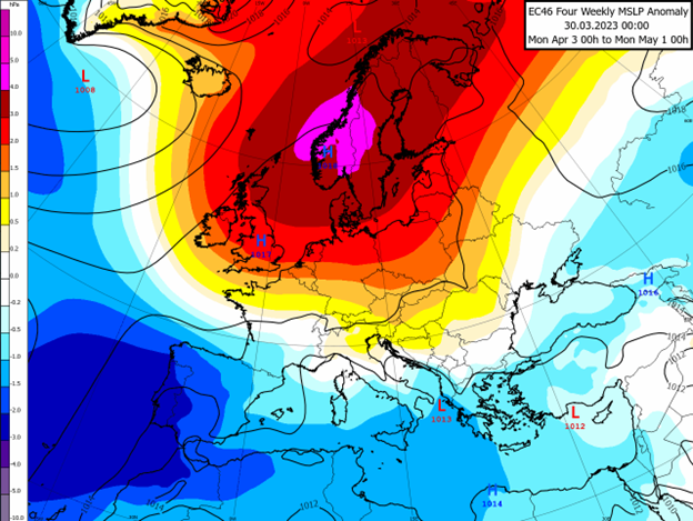
The map above is from a recent longer-range weather model showing pressure anomalies across Europe. The red shading around Scandinavia indicates the higher pressure compared to normal for April, which would favour drier and settled weather for the UK as well as much of Northern Europe. This is the preferred weather pattern for the Easter weekend and into next week, but this may continue for longer or re-emerge later in the month.
In this pattern, we can expect calm and settled weather with some large temperature swings between day and night, due to clearer skies from the high pressure. The high pressure will tend to transport cooler air masses in place, but this time of year with the longer days and stronger sun, the afternoon warming tends to cancel this out.
The risk for next week and beyond would be for the high pressure to build further East towards Russia, in this case rain-bearing weather fronts and low pressure, promoting April showers, would be more likely to creep in over the British Isles. In any case, Ireland and Scotland are generally more at risk of wetter weather whilst Southern and Eastern areas should be closer to the influence of high pressure.
The latter half of April and heading into May should see high pressure begin to make way for Atlantic low pressure systems more frequently, with wetter and changeable weather but keeping things mild, as the winds would tend to blow from the South and South-West. Again, the risk here would be for high pressure to remain somewhere in Northern Europe, giving us similar weather to this week.
About this author