After record-breaking temperatures in July, August began with a continuation of the hot and dry summer weather with plenty of +30C days. As expected, this has led to widespread restrictions on water usage and the declaration of droughts. Eventually things began to slowly cool down and thankfully a more unsettled September is forecast to bring some much needed rain, especially for the driest areas in southern England.
We begin the month with exactly what’s required for unsettled weather – low pressure. This is typical of autumn weather as the jet stream begins to strengthen. Unfortunately, it’s not what you want to hear if you have any weekend or holiday plans.
A low pressure centre is currently forming in the atmosphere above us, causing air to rise and produce widespread cloud and showers. This is the main story for the weekend and first full week of September. Some heavy downpours along weather fronts will also arrive from the south and west, though there will be increasing chances for sunny spells later in the week.
Unfortunately, forecasting beyond next week is tricky due to increasing activity of the Atlantic hurricane season. Tropical cyclones form over very warm waters near the equator in the Atlantic, Indian, and Pacific oceans during the summer and autumn. These produce heavy rain and very strong winds, which - when strong enough to exceed certain criteria - are termed hurricanes. The exact location where these tropical systems form and the path they take across the Ocean is important for our weather in Western Europe because they can determine the strength and position of the jet stream (the main driving force of our weather in the UK).
These tropical cyclones can even cross the Atlantic over to us. Although they are too weak for any hurricane-force winds once they make landfall in Europe, they can still cause a few days of severely wet and windy weather.
On the other hand, if these tropical cyclones and hurricanes remain further out in the Atlantic they can promote high pressure building in north-western Europe which would lead to some warmer and more settled weather.
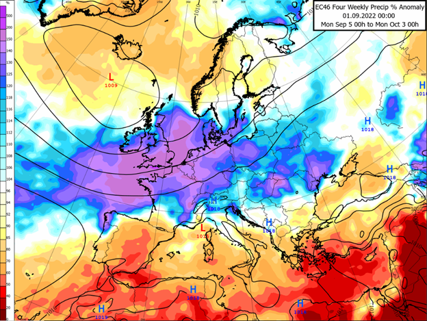
Despite the uncertainty with the hurricanes, the computer models are predicting unsettled weather for the rest of the month, with occasional high pressure building in the south. The map above shows the forecast rainfall anomalies for this September - as you can see, purple and blue shading, indicating wetter than normal weather, is expected over much of the UK and Ireland. Temperatures may be slightly on the warm side for this time of year, but gradually cooling down as is usually the case in autumn.
Be sure to keep an eye on any hurricane activity in the news as this will be increasingly important for our weather later in the month and into October.
About this author